The Nomads Outdoors Group Inc.
Powered by

** Nomads email addresses have changed to the format LeaderFredN@nomads.org.au, and may go into your Junk Folder as a result. See Some Recommendations about Nomads Emails to prevent that **
The Nomads is a social outdoors group for gay and gay-friendly men of all ages. It also welcomes those from the lesbian, bisexual and transgender communities, and anyone who shares its objectives of tolerance and acceptance.
 Check out the upcoming Nomads events
 If you don't receive a confirmation email, check your Spam folder!
  Check your currently active bookings (login required)
The Nomads would like to acknowledge the traditional custodians of the lands on which we meet for our events, and we pay our respects to Elders past and present.
Events
View all
Aug
04
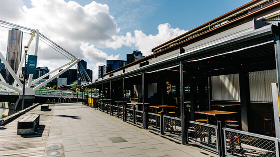
August Social Night @ The General Assembly (South Wharf)
The General Assembly
19:00 – 21:00
Our regular monthly social night - this month at The General Assembly, South Wharf.
GRADE: Social.
ACTIVITY DESCRIPTION: Join us for our monthly social evening where members can enjoy a meal, talk about upcoming events, compare notes on past activities and float ideas on events they would like to see run. Do you want to see more of a particular activity, or do you have a particularly favourite area of Victoria you would like to share with others? Do you have an idea for a walk we haven't done before? If so, we'd love to hear from you. Everyone is welcome – new members are especially invited to any of the monthly Nomads social evenings.
See The General Assembly website for more details, including their menu.
BOOKING: By Sunday 2nd August. To register, click on Get Tickets.
Unsure if you've already booked? Click View my bookings.
MEETING TIME | LOCATION: 7pm at The General Assembly, 29 South Wharf Promenade, South Wharf.
Beware: If searching your map app, take care to search for the correct General Assembly (not the one at Freshwater Pl nor the one in William Street).
MAP REFERENCE: Google map maps.app.goo.gl/Mu61ZPNZ4Pijbaiz5.
PUBLIC TRANSPORT: The General Assembly is a 14 minute walk from Southern Cross Station (or 19 minutes from Flinders Street Station). Alternatively, take tram 12, 96 or 109 to stop 124A (Casino/MCEC/Clarendon St).
LEADER: Richard C. | Email LeaderRichardC@nomads.org.au if you have any questions.
Members can access leader contact details under Members | Leader Contacts when logged in to the website.
HOME BACK TO LIST OF EVENTS MEMBERSHIPS
Aug
09
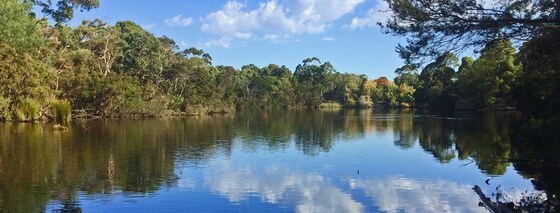
Blackburn Lake Loop Walk
McCubbin Park
11:15 – 15:00
A leafy oasis in the heart of Melbourne's outer suburbs
GRADE | LENGTH | TYPE: Grade 2: Easy 8 km circuit walk (graded according to the AWTGS: Australian Walking Tracks Grading System).
ACTIVITY DESCRIPTION: A leafy oasis in the heart of Melbourne's outer suburbs, Blackburn Lake Sanctuary is a brilliant spot for a relaxing stroll under the canopy of remnant bushland. We'll initially pass through some leafy suburban streets to Furness Park, then follow the creek looping around the tranquil lake, offering a peaceful escape where the sounds of the city are replaced by the calls of local waterbirds. The paths are predominantly wide, flat, and well-maintained gravel. There is plenty of shade provided by the towering eucalypts, which keeps the track cool even on a warmer arvo. While the main loop is quite straightforward, there are numerous side tracks through the wattle trees that allow you to extend your exploration of the bushland.
Bird enthusiasts will have a field day here; the lake is a sanctuary for diverse species.
BOOKING: By Friday 7th August. To register, click on Get Tickets.
Unsure if you've already booked? Click View my bookings.
MEETING TIME | LOCATION: 11:15am at McCubbin Park. Near roundabout at Central Rd/Lake Rd.
PUBLIC TRANSPORT: Take Belgrave or Lilydale train to Blackburn Railway Station. The latest is 10:06 from Flinders Station, or the loop. It's less than a 1 km walk or bus (#736 @ 11:05) from there to the start point. The start has been delayed to match the bus.
MAP REFERENCE: Google map: https://maps.app.goo.gl/tpCYKVvsFMgvi42N7
FOOD: Carry lunch, snacks and a litre of water.
APPAREL | FOOTWEAR: Comfortable walking boots and dress according to the weather forecast.
LEADER: Richard C. | Email LeaderRichardC@nomads.org.au if you have any questions.
Members can access leader contact details under Members | Leader Contacts when logged in to the website.
HOME BACK TO LIST OF EVENTS MEMBERSHIPS
Aug
09
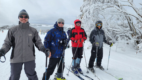
Ski Week at Falls Creek
Cosela Alpine Club
09 Aug 2026 13:00 – 16 Aug 2026 10:00
A full week of cross-country skiing, downhill skiing and/or snowboarding, staying in a cosy lodge at Falls Creek. Stay the full week, or part thereof.
GRADE | LENGTH | TYPE: Your choice (choose slopes and equipment to match your skills) – cross-country skiing, downhill skiing and/or snowboarding.
ACTIVITY DESCRIPTION: A full week (or part thereof) ski trip to Falls Creek is planned for a week Sunday 9th to Sunday 16th August. We will be staying at the cosy Cosela Alpine Lodge, which provides ski-in ski-out access from Wombats Ramble with no oversnow transport requirements. This will be a cross-country ski, downhill ski and/or snowboard week leaving Melbourne on Sunday and leaving Falls Creek the following Sunday.
BOOKING: Please get a Nomads ticket ASAP by clicking on Get Tickets, as there are limited beds now available. It's advisable to email LeaderLesB@nomads.org.au after you book, so he can advise what beds are available and organise payment.
Unsure if you've already booked? Click View my bookings.
FURTHER INFORMATION: www.cosela.com.au/Winter/index.html.
MEETING TIME | LOCATION: Sunday afternoon, Cosela Alpine Lodge, Falls Creek.
MAP REFERENCE: Melway Map X922 grid H10 | Google map goo.gl/maps/V7fBUEiNBb62.
GETTING THERE: There are coach services from Melbourne, Mt Beauty and many other locations to Falls Creek. There are long-term parking facilities in Mt Beauty if you don’t wish to take your car up the mountain. If driving, take the Hume Freeway (M31) to Wangaratta then the Great Alpine Road (B500), turning off to Mt Beauty. On arrival at Falls Creek you should request to unload your luggage at the steps beyond the CFA station, which is lit at night. As you are staying at Cosela, you don't need oversnow transport. After unloading, you will return to the attendant to be directed to a parking place. Cosela Lodge can then be reached by travelling up the steps and across Snowgum Lane (see map at www.cosela.com.au/Winter/Map.html).
DISTANCE | TIME FROM GPO: 391 km, 4.5 hours.
FOOD: It's advisable to bring food for the period of your stay; group catering arrangements will be organised after registration. Breakfast cereal, milk, bread, jam, condiments, tea and coffee are provided by the lodge. There’s a local food store for last minute supplies and oversights.
COSTS: You can come for the full period or part thereof:
ACCOMMODATION MON-THU: The accommodation cost is $125 per Nomads member per night.
ACCOMMODATION FRI-SAT: $280 for Friday plus Saturday night (i.e. $140 per night, but payment is required for both nights if either is required).
BOOKING FEE: There is also a $3.50 service booking fee.
BUS - MOUNT BEAUTY TO FALLS CREEK: The bus fee is $79 Mount Beauty to Falls Creek return if you decide to park in Mt Beauty bus depot a secure parking fee of $84 for the 7 nights.
FALLS CREEK PARKING: The parking fee at Falls Creek was $469 for the 7 nights in 2025. This will be updated once this year's price is known (plus you will need to carry snow chains).
NON MEMBERS: Not a Nomads member? Purchase a temporary one-month membership before getting your tickets (cost $8).
APPAREL | FOOTWEAR: Bring sheets and pillowcases, towel, washer and toiletries, plus ski gear to suit all possible conditions (or hire it in Mt Beauty or Falls Creek). Don’t forget warm, comfortable clothing for after-ski activities. If driving you will be required to carry chains (these can be hired in Mt Beauty), and you should ensure your radiator has antifreeze.
LEADER: Les B. | Email LeaderLesB@nomads.org.au if you have any questions.
Members can access leader contact details under Members | Leader Contacts when logged in to the website.
HOME BACK TO LIST OF EVENTS MEMBERSHIPS